Wednesday, June 29, 2011

Just a quick update

Hello from Dawson City,


We are doing well.    Just wanted to let my followers know that there will be more updates in the future about Alaska, Chicken, Top of the World Highway and Dawson City.

The north is beautiful, but many services we take for granted are sporadic here.   For example the Internet; service is through satellite.  All places have bandwidth restrictions and uploading of pictures is not allowed.  The local library has maxed out its allotment for the month, so no Internet till next month.    Two days ago there was a lightening strike into a cellular tower, and so there was no cell phone coverage, Internet, interact, bank machine, TV, regular phone etc. .  "Welcome to the north", the locals all said.  I will do all the uploading when we get somewhere with good Internet services. 

Today Henry and I will be headed towards Inuvik,   NWT.   We expect to be back in Dawson City within a week. 

Hope everyone is having a great summer.    Happy Canada Day ! 


Sunday, June 26, 2011

Fairbanks - The Golden Heart City


The City
        After leaving the Denali Park area, we head north to Fairbanks.  On the drive I realize we will be in Fairbanks for the Summer Solstice.  Earlier when we had crossed the border into Alaska, we had stopped at a visitors centre and were told about a fun summer solstice in Fairbanks.  I had thought we would be in Dawson City by Solstice, so I did not really pay much attention.  Now that we were about to arrive in Fairbanks on June 20th, I think great, lets stay two nights and take part in the Solstice festival.

        We check in at the RV park for two nights and proudly ask where is the Summer Solstice festival held.  The answer, if was downtown on the 19th.  WHAT?  I thought the Solstice was the 21st?  Apparently not in Fairbanks, it is the 19th.   Who knew? 


Let me tell you about the city of Fairbanks; population 31,000, over 90,000 with the surrounding boroughs and 16,000 military personal based here at any given time. The result, a sprawling city of box stores and strip malls. 

           Founded in 1901 as a trading post.  The history is rich in gold mining.  The natural resources of gold and oil, still drives the economy.  

The downtown is, well lets say, you aren’t missing anything. 

          This northern city of Alaska is famous for its long cold winter and hot short summers.  Maybe that is why the Summer Solstice is on the 19th, that gives them two more days of summer. 

The city is located on the banks of the Chena River, which used to be the main form of transportation during the melt.   The weather has been hot, and the mosquitoes love it hot, so I have finally fallen victim to mosquito bites.  There have been tons of those creatures around but the repellent was keeping them away till now.  I have learnt to use Watkins Insect repellent as my moisturizer, works great! 

Wednesday, June 22, 2011

Mount McKinley Summit elevation 20,320 feet - 6,194 metres


Talkeetna Airport - basically each airline had own building
       Mr. McKinley is the tallest peak in North America, attracting over 1000 mountain climbers annually from around the globe.   The climbing season is from early spring to late June.  As soon as the snow from last winter has melted, the crevices of the glacier are exposed and it becomes too dangerous to climb.   Most of the climbers are flown to base camp; their success rate about 65%, just running out of time is the biggest problem.  There are fatalities annually, this year 5 people have died trying to climb the mountain, one just the day before we got to Denali National Park.
 The flight services are based out of the little historic town of Talkeetna because it is air distance closer to Mt McKinley then the visitor’s portion of Denali Park, which lies north of the Alaska Range. Weather is looking promising, blue skies greet us as we rise.  
We back track to Talkeetna for our reserved flight around Mount McKinley.  Caroline and Neal gave us the flight as a gift, wow and what a gift!   Thank you very much. 


If you ever wondered what skies and tires on a plane look like


        We arrive at the Talkeetna Airport and Check-in. (Oh the dreaded check-in for small aircraft.  I really do not want to be weight with all my gear on, oh well I will never see these people again, and Henry can’t hear what they said anyway.  Mental note to self – need to lose weight. )


Leaving Talkeetna

See the shapes of the lakes and landscapes

        We get special glacial boots to cover our foot wear.  The pilot (hunk and in his 30’s – ghees young enough to be my son) walks us out to the plane.  Yeah red, my favourite colour!  Has to be a good sign – right?  


See the iron in the river colour

        Our Pilot, Ryan,  instructs us to tighten our seat belts well, as there is turbulence ahead.  The weather is so warm that the ride will be bumpy and as we approach the Alaska Range the winds can be rough. 
        The first part of the flight is over the valley, and  like everything else in Alaska, was formed by a glacier.  From the air it is easy to see the effects that the glaciers had and still have. Several lakes were formed. all elongated in the same direction as the glacier slid. 

A lot of swamp land, making for happy moose. We can see many homes out in the wilderness, with no road access.  The pilot tells us that these people fly in and land on the lakes to get to their homes.
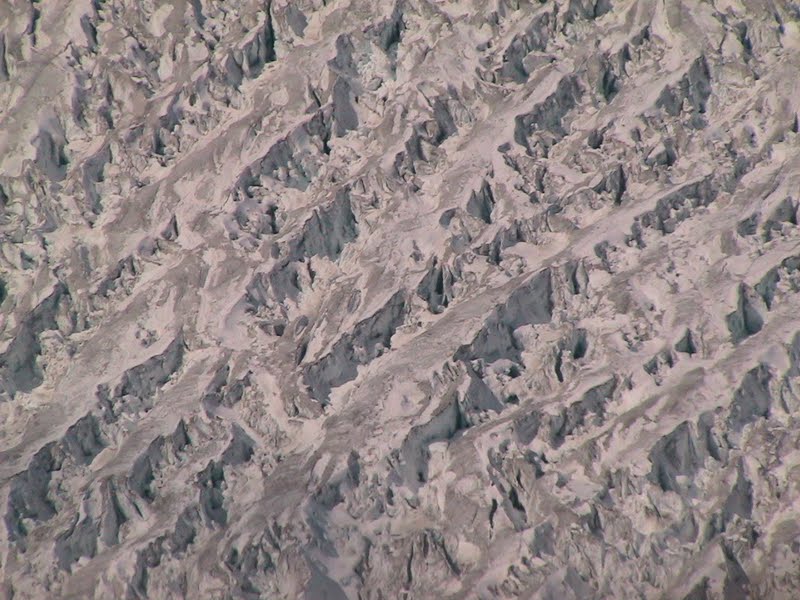
 As we approach the mountain range we see existing glaciers and how they have dropped their sediment along the way.  It is like watching the earth’s history unfold.  

shows how the glacier is forming the land
As we fly around the mountain our pilot pointed out how we can see the different colour rocks that make up these ridges and shows how these mountain ranges were formed.  The forces that lifted Mount McKinley—the seduction of the Pacific plate beneath the North American plate—also raised great ranges across southern Alaska. As that huge sheet of ocean-floor rock plunges downward into the mantle, it shoves and crumples the continent into soaring mountains. 


  Ryan flew around one particular ridge to show us the dark, almost black sedentary rock of the Pacific plate and on the other side of the cliff a lighter colour rock of the North American plate.  It was absolutely amazing. 
 Mount McKinley, in particular is uplifted relative to the rocks around it because it is at the intersection of major active faults that move rocks laterally across the Earth's surface which allow the deep buried rocks to be unroofed more rapidly compared to those around them.


Our flight path takes us through passes; the rock formations seem so close I am sure the wing tips are just inches away.  Okay I know they are further away, but it sure looks scary.  We fly over base camp for the climbers, and can actually see the tracks left by recent climbers.  Ryan tells us that approximately 200 climbers are on the mountain at this time.  


We are extremely lucky that the weather has cleared enough that we can fly around to the north side of Mt. McKinley.   The north side has one of the longest vertical drops in the world.

Landing on the Ruth Glacier, a frightening as much as exciting experience.  The pilot announces the approach and I have great confidence in this YOUNG man, but as I see the wing of the aircraft seemingly to tickle the rock cliffs of the surrounding mountain, I think “ Well I had a good life, my kids are grown and can take care of them selves, if he crashes into the rock face I hope for a quick end”  


  Before I can finish the thought,  we clear the rock faces and the amp theatre opened up in front of us as the plane continues to descend.  Phew.

“Please tighten your seat belts, this landing will be rougher then what you are used to” comes over the headset. 
I can not express in words how exciting it was.   Me, grown up as a couch potato in the ghetto of Montreal, How did I get to this place?  How did I become brave and lucky enough to do this outrageous thing?  WOW.  I thought we had done some wild things in the past, but this takes the cake.


 As we climb out the plane (using a flimsy step ladder) and first step on to the mushy snow and look in awe at the massive amp theatre of mountains I am shocked at the size of the place.  We are standing on Ruth Glacier, beside Mount McKinley with about 20 other people and 3 planes.  


Ruth Glacier’s upper reaches are 4.8 km below the summit of Mount McKinley. The glacier's "Great Gorge" is 1.6 km wide, and drops almost 600 m over 16 km, with crevasses along the surface. Above the surface on both sides are 1,500-m granite cliffs. Ryan tells us from the top of the cliffs to the bottom of the glacier is a height exceeding that of the Grand Canyon. Ruth Glacier moves at a rate of 1 m a day and was measured to be 1,158 m thick in 1983.
Surrounding the Ruth Gorge are many mountains of the Alaska Range, including the Moose’s Tooth another favourite among the climbers.


  Walking on the glacier is not easy; the area is very lump, as you are walking in tracks made by the landing planes.  The snow is granular, like ice snow crystals.  Ryan measures the depth of this year’s snow as 1.75 m.
            I am pumped with adrenaline from the experience.  We were so lucky to have the opportunity to do this.
            Standing on Ruth we watch another plane take off.  He rolls along the ice surface and suddenly disappears and then reappears.  It is hard to explain, but the glacier makes a dip so the planes actually take off down hill and then become airborne and is in sight again.   


On our way back to Talkeetna Airport

Water left behind by a glacier

Evetually will be a lake that looks like this

Can you guess what this is


            After a while it is time for us to take off and head back.  Reluctantly we climb back into the plane and Ryan takes us on a straight line back to the Talkeetna airport. 
This is the same thing
            The time just flew by.   Would I do it again?  In a heart beat.

Tuesday, June 21, 2011

DENALI NATIONAL PARK (June 14-18th) Sunset 12:19 AM


Denali National Park and Preserve is Alaska’s major tourist attraction, drawing over 400,000 people each summer.   Thanks to the good advice from our friends Monica & Lawry, we made reservations back in February.  Our base camp is Teklanika Campsite located 29 miles from the entrance.


Private vehicles are not allowed past mile 15 within Denali National Park, only the few lucky enough to get a reservation are allowed to drive in to Teklanika Campsite.  No private vehicular travel is permitted beyond this point.  You are given a permit to drive in and one to drive out on the day of your departure; you may not use your vehicle while in the parks.

Having set up our camp in this vast wilderness, surrounded by black spruce trees, I am mostly impressed by the absolute quiet, only the birds chirping in a distance.   Quiet, the absence of sound, Tranquility, allows what ever sound there is to travel far and sound loud, hence quiet is oddly noisy.
First class transportation within Denali
 Denali has a public transportation system to take visitors into areas where private vehicles are not allowed.  These old green school buses have designated stops but can also be flagged down anywhere on the roads.  The end of the road is Katnishna, at 92 mile mark.   When making campground reservations back in March we had been advised to book our tickets for this bus on the 15th of June. All night it rained and did not let up in the morning.  So we dawned our raingear and boarded our bus punctually at 8:55 Am
First day out in Denali get to use my new rain suit. 

From the location of our campsite is only 64 miles to Katnishna.  I did not understand why this trip should take 10 hours but I quickly learn.    The dirt road narrows, to one lane, several potholes and dozens of blind corners where the bus can only slowly creep along.  All eyes are focused on the landscape trying to spot wildlife.  Once some animal is spotted the bus grinds to a halt, till all passengers have their fill of picture taking.


The bus driver, Jeremy a farmer from New Hampshire, makes sure no arms or heads pop out the bus windows.   We are caged in our green school bus enjoying the wilderness and seeing the local animals enjoying their freedom.   Jeremy also seemd to like to hit each and every pot hole dead on. 

Caribou
We had a successful venture because during that day we managed to see; caribou, Dahl sheep, grizzly bear, moose and wolf.  We are only allowed off the bus at the official rest stops, all just 10 minute breaks except for one 30 minute stop.


Dahl Sheep

Grizzly sitting on top of hill with her cub

Mama moose with her two young ones

Blonde Fox running across road


Polychrome Pass the road is carved out of the rocky side of the Outer mountain range.  It is single lane with vertical drops of over 1000 feet, not a ride for those afraid of heights.

One lane road around pass, look for Dahl sheep on rock

Road along edge of Polychrome pass
  I imagine the pass got its name from the multicolour rock, riche in iron deposit; it is all shades of rust, orange, red and purple.   As we cling to the edge of the multicolour rock in our green bus we can look over the valley that was formed more then 20,000 years ago.

We seen planes, boreal forest, taiga and tundra.  As we climb stony hill and drive through the Pass the highest elevation pass, 3,950 feet in Denali, the rains turns to snow, no mountain peaks to be seen this morning.
Snow at Stony Hill, June 15, 2011

As we approach the Eielson visitors centre, across the driver’s CB radio comes the warning to all bus drivers that there are bears in the parking lot.   We still have 14 miles to travel to get there. Fortunately the bears waited for us.
Mama Grizzy and her twins

A sow and two yearling cubs just walked up the hill to the edge of the visitor centre parking lot.  The rangers scrambled to assure a safe distance was kept.  It was an amazing experience to see grizzlies from less then 100 metres away.

 This was not our only grizzly sighting on this trip; we saw four on this day and 2 more the following day.
In the afternoon the rain stopped and the views were much improved but there is no hope in seeing Mt. McKinley.   It is a long day but we saw so much of the wilderness, it gives a new perspective of the earth, how vast it is and how old, and what a short moment in time we individually have on it.

By Polychrome Pass
Denali was mostly formed from a huge glacier.  In this latitude & elevation the park varies from a boreal forest of black spruce, to a willow covered taiga and rugged tundra of stinted growth.  The rivers and not full of rushing waters as I would have expected but more like a twisted braid of little streams of glacial melt through a wide expanse of glacial rock basin.  Up the hill sides is vegetation, willows, manly varieties of flowers, till you reach the rocky etched in stone faces of the summits towering above it all.

Exhausted from the growling bus ride we cook a quick dinner on the campfire.

  Our neighbours on the campground and who were also on our bus, is a Scottish couple from North Caroline.  They immigrated to the US 13 years ago.  We enjoy a pleasant evening talking about places we have travelled to.  They as well have been to Peru.   

Henry in Denali

Wonder Lake near Katnishna.  On a clear day they tell us we would have been able to see a reflection of Mt. McKinley in the lake. 


        The next day we rise to beautiful clear sunshine, so once again we climb onto the old green school bus and ride this time only to Tolgat.

Antlers from tow bulls that locked together and died. At Tolgat Visitors Centre


We have our picnic lunch and the hike the glacial river bed.
hiking

hiking along a glacial river bed

The flowers blooming are amazing, as they grow out of rock.  Due the clear skies we see the mountain range tops but no Mt. McKinley.


Just some of the flowers.  I am thinking of doing a chapter on just flowers.
        The evening we spend chatting with a couple from California that we had camped beside at Boya Lake in BC.  Such a small world this big planet of our is.

 
 While driving out of Denali Park we finally get to see the white snow covered peaks of Mount McKinley.   
Mount McKinley in the background
 

 They say that only 30% of the visitors to the park ever get to see this giant of a mountain that towers over all the other peaks.  It is so high that it has its own weather systems, and frequently a cloud forms around it and develops to a snow storm. 


Bullwinkle

Bullwinkle with girlfriend
  Just as we are about to leave the park, we see two moose very close to the road, but slightly hinded in the brush.